Rated: 5.0/10 (2D1N)
Mount Kinabalu, Malaysia tallest mountain with the height of 4095m but it definitely not the tallest mountain in South East Asia. To date of this writing, it is still the tallest mountain I had hike. Though it is Malaysia tallest mountain, it actually one of the "easy" mountain out there compare to other more virgin mountain with height elevation less than Mount K, I would usually tell people, if you can hike Gunung Nuang via Hulu Langat / Pangsoon without any problem, you are good for Mount Kinabalu. But this mountain is also one the most expansive mountain to climb... Worth it or not, I leave that up to you to judge.
Mount Kinabalu, Malaysia tallest mountain with the height of 4095m but it definitely not the tallest mountain in South East Asia. To date of this writing, it is still the tallest mountain I had hike. Though it is Malaysia tallest mountain, it actually one of the "easy" mountain out there compare to other more virgin mountain with height elevation less than Mount K, I would usually tell people, if you can hike Gunung Nuang via Hulu Langat / Pangsoon without any problem, you are good for Mount Kinabalu. But this mountain is also one the most expansive mountain to climb... Worth it or not, I leave that up to you to judge.
This mountain required you two days to hike since it their house rule. It give you time to acclimatize to the weather up there anyway. There only one tour agency if you are coming from Peninsula Malaysia, which is the "Amazing Borneo Tour" and booking thru them was actually very easy. They use Whatsapp to communicate with you and their reply are quite fast. They will also provide transport (usually only from Kinabalu town) to Timpohon.
Stuff I brought with me:
2 500mL water bottle (refill water at Laban Rata)
WindBreaker
Long Jone / Inner Thermal Wear (both Pant and Shirt)
2 set of cloth (3 set if you think it going to rain while going up and down)
Some Raisin
Some Sweet and lolipop
Sandal and Kampung Adidas
Rented hiking stick
GoPro and extra battery (cold air drain the battery dam fast)
Side note :
- The stuff I brought with me is comfortable for me only, if you think it not enough, don't be afraid to add on. Seriously, don't be afraid.
- The amount of water you need to bring up vary person to person, 1.5Litre is usually recommended.
- Only shoe is allow while hiking up Mt Kinabalu unless you can convince ur guide that you can climb with sandal. And also, the entrance guard won't allow anyone to climb without shoe.
- I hike up to Laban Rata with sandal but kampung adidas to peak due to coldness.
- They serve all your normal meal including lunch while you hike up to Laban Rata, you only need to bring up snack food or anything you want to eat at the peak.
- The peak can get as cold as 2 Celcius but it won't be the temperature that kills you, is the wind (if you unlucky, plus the rain)...
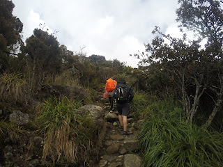
On day one, we started our hike at an elevation of 1500m at Timpohon gate around 9.30am+ after all the briefing from our two guide (there were six of us). Our trail start of with a waterfall known as Carson Waterfall and it was small waterfall, anyway, the hike went on through the jungle man-made stairs. Yes, most of the trail to Laban Rata has well-prepared pathway for you, hence, the "easy" difficulty of the hike.
(2017 version)
The trip up to Laban Rata wasn't much but there are occasionally a few nice scenery to stop by and enjoy. The whole journey to Laban Rata was all the way uphill though, similar to Datuk or Kutu but make easier with all the stair. The total distance to Laban Rata is around 6km of continous uphill (three time of Datuk maybe?). We took a total of 5.5 hours to reach Laban Rata.
(2012 version)
5 years ago, the view as I recall did not change much and some of the pathway, surprisingly I can still remember especially Layang-Layang. Though, during that time, it took me 7 hours to reach Laban Rata and we were actually half an hour late as we needed to reach by 4pm for the "Via Ferrata" briefing. Thankfully, they waited for us and manage to get our briefing for it. This hiking section was a bit worrying for me as it was raining before we went to bed! All I did was say some prayer and hope for the best the next day...
On both occasion as we reach Laban Rata, I did had a minor headache which I suspect it a very mild altitude sickness maybe, but taking dinner and went to bed early help. The dinner they prepared were buffet style and it was nice on both time. Do note, they do not serve water up here, you either boiled water from the toilet (which I had no problem drinking it) or buy from them (which can cost up to RM10++ per can). Hot shower is limited but I never bother to used it anyway.
Here how our timing look like:
9.30am : Hike start
9:40am : Catson waterfall
10.00am : 1st Checkpoint (0.8km)
10.30am : 2nd Checkpoint (1.5km)
10.40am : Nice view for a while
11:50am : 4th Checkpoint (3.0km+)
12.30pm. : Layang-Layang (4.0km) (30-45 min rest for lunch)
In between : There a lot of nice scenery as the forest start to change and open up.
3.00pm : Laban Rata
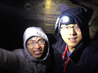
We start sleeping around 8-9pm to prepare for a very early hike which start at 2.30am as this is when the gate open. At 1.30am, we all woke up and wash up. After that we head to Laban Rata resthouse to have our supper / very early breakfast at 2am. After the guide prep and brief us, we all started our hike at 2.30am once the gate open.
(2017 version)
The hike start out smoothly and sweetly, weather was good and the sky was clear... As I want to reach the peak before the sunrise and with the guide blessing, me and one of my friend decided to chase for the sunrise at the peak. The path to the peak is easy as all you got to do is follow the rope. We occasionally stop break and just enjoy the view where to see line of light from the hiker headlamp and with the city light at the background and the faint star light, it was definitely breathtaking! Once we reach Sayat-Sayat hut, we show our ID card and inform that our guide were with the other, we took a few minutes break and continue chasing for the sunrise peak.
All was great until some not good thing happen.... It started raining... Initially, it wasn't to bad but along the way, it gotten quite bad. The rain got truly "terrifying" around the 7.5-8.0km mark where our visibility was down to around 5-7m (my headlamp has a range of around 15m), though the rope was still very visible, I was only worry that the other half of the group might have been stopped at Sayat-Sayat hut due to the rain and ask to turn back... If that really happen, I know I can't disappoint my last friend who was following me... We push on into the cold darkness...
5.20am, we started see-ing hiker coming down the path, fearing for the worst that we might get turn back after all that, we continue on in our wet thermal inner ware cloth and sock. My body was starting to feel cold and this was not a very good sign...
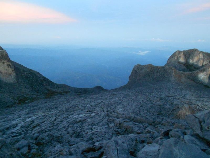
5.30am, we started see-ing more hiker coming down but our hike were suddenly halted by hikers which look like they queuing for something... I was not aware we were at the peak until someone pointed out that we have indeed reach the peak! We quickly line up and took a few photo only as it was cold and wet. After that, we headed down a bit and find some rock to hide from the wind (it didn't work btw) and wait for the other to come up... Unfortunately, if was too cold and wet and could only manage to wait 20minutes...
While we were heading down, we met our group! Though, it was only two of them as the other two had no choice but to turn back due to weather. As we headed down to Laban Rata, the weather did clear, we manage to took some good photo and just enjoy the view as we headed down. We regroup at Sayat Sayat hut and went down to Laban Rata with good weather and view. Though it only last during that time and the rain and wind came back again when we were going back to Timpohon... Nevertheless, all of us make it to the base before the penalty time and we all had our certificate that we reach the peak of Mount Kinabalu (Yes, once you reach Sayat Sayat hut, you technically also reach the peak of Mount Kinabalu)
(2012 version)
The hike during this time started out quite rough as I remember we started a bit late and it was raining a little bit. Though me and my brother was not aiming to reach the peak before sunrise, but I was definitely having a hard time trying to reach the peak. The weather was actually good but it was just fatigue that was dragging me down.
We manage to reach the peak by 6.30am where the sun has already risen up. I remember the sunrise here is a little bit similar to the sunrise in Broga Hill, but it was definitely more breathtaking than the one in Broga Hill. We ate some food at the peak and unfortunately I did not know how to enjoy the view that time and moment later, we headed down even without taking the peak signboard.... One of the reason why I wanted to rush down is because we were taking the "Via Ferrata" route!!
Sadly, my memory failed me here and I don't remember how long or far was the route was.. But all I know it the route has a very scenic view, a very different one indeed compare to your usual route. Also note that this route is really not suitable for people who is afraid of height as it is really at the edge of the mountain you climbing! Nevertheless, it a very different experience here and if you do have the money and only one to come to Mount Kinabalu once in your lifetime, then do take this route!
On both occasion, thanks God!! The mountain did provide me with marvelous view and a great hiking trip! Even though the 2017 hiking trip is one of the worst weather in my hiking life, it was still an experience for me! (hopefully it won't happen to any of you reading this!!)


(2017 version)
The hike start out smoothly and sweetly, weather was good and the sky was clear... As I want to reach the peak before the sunrise and with the guide blessing, me and one of my friend decided to chase for the sunrise at the peak. The path to the peak is easy as all you got to do is follow the rope. We occasionally stop break and just enjoy the view where to see line of light from the hiker headlamp and with the city light at the background and the faint star light, it was definitely breathtaking! Once we reach Sayat-Sayat hut, we show our ID card and inform that our guide were with the other, we took a few minutes break and continue chasing for the sunrise peak.
All was great until some not good thing happen.... It started raining... Initially, it wasn't to bad but along the way, it gotten quite bad. The rain got truly "terrifying" around the 7.5-8.0km mark where our visibility was down to around 5-7m (my headlamp has a range of around 15m), though the rope was still very visible, I was only worry that the other half of the group might have been stopped at Sayat-Sayat hut due to the rain and ask to turn back... If that really happen, I know I can't disappoint my last friend who was following me... We push on into the cold darkness...
5.20am, we started see-ing hiker coming down the path, fearing for the worst that we might get turn back after all that, we continue on in our wet thermal inner ware cloth and sock. My body was starting to feel cold and this was not a very good sign...
5.30am, we started see-ing more hiker coming down but our hike were suddenly halted by hikers which look like they queuing for something... I was not aware we were at the peak until someone pointed out that we have indeed reach the peak! We quickly line up and took a few photo only as it was cold and wet. After that, we headed down a bit and find some rock to hide from the wind (it didn't work btw) and wait for the other to come up... Unfortunately, if was too cold and wet and could only manage to wait 20minutes...
While we were heading down, we met our group! Though, it was only two of them as the other two had no choice but to turn back due to weather. As we headed down to Laban Rata, the weather did clear, we manage to took some good photo and just enjoy the view as we headed down. We regroup at Sayat Sayat hut and went down to Laban Rata with good weather and view. Though it only last during that time and the rain and wind came back again when we were going back to Timpohon... Nevertheless, all of us make it to the base before the penalty time and we all had our certificate that we reach the peak of Mount Kinabalu (Yes, once you reach Sayat Sayat hut, you technically also reach the peak of Mount Kinabalu)
(2012 version)
The hike during this time started out quite rough as I remember we started a bit late and it was raining a little bit. Though me and my brother was not aiming to reach the peak before sunrise, but I was definitely having a hard time trying to reach the peak. The weather was actually good but it was just fatigue that was dragging me down.
We manage to reach the peak by 6.30am where the sun has already risen up. I remember the sunrise here is a little bit similar to the sunrise in Broga Hill, but it was definitely more breathtaking than the one in Broga Hill. We ate some food at the peak and unfortunately I did not know how to enjoy the view that time and moment later, we headed down even without taking the peak signboard.... One of the reason why I wanted to rush down is because we were taking the "Via Ferrata" route!!
Sadly, my memory failed me here and I don't remember how long or far was the route was.. But all I know it the route has a very scenic view, a very different one indeed compare to your usual route. Also note that this route is really not suitable for people who is afraid of height as it is really at the edge of the mountain you climbing! Nevertheless, it a very different experience here and if you do have the money and only one to come to Mount Kinabalu once in your lifetime, then do take this route!
On both occasion, thanks God!! The mountain did provide me with marvelous view and a great hiking trip! Even though the 2017 hiking trip is one of the worst weather in my hiking life, it was still an experience for me! (hopefully it won't happen to any of you reading this!!)
 |
| Beautiful ain't it?! So it the Mountain!! |
(2017 VERSION!)


(2012 VERSION!)


Correction: The hike to Laban Data took 7 hours and to the peak roughly 4 hours.
No comments:
Post a Comment